
UPDATES:
We forgot to mention on the way to Georgetown, SC we got boarded by the Coast Guard. They were just doing a routine safety check and we didn’t even stop. They hopped on and we easily passed. Before they came on I told them we just had a safety check done and had the Coast Guard sticker on the side of the vessel. I guess they were bored cuz they still wanted to do their own check. We were kinda hoping the Coast Guard sticker showing we had already passed a safety check would keep the Coast Guard off of us but owell.
Also we have not been so lucky to avoid repairs during this trip we just haven’t been reporting them so much and we apologize. Here’s our list
Fixed:
Handheld VHF battery charger lost = Purchased a new one
Driveshaft bolts came out = We were spinning on one driveshaft bolt at one point but now have them all tightened back up and replaced the one bent bolt. We plan to replace the other three as well.
Stuffing Box came undone = We bought new packing and repacked the stuffing box. No more water flowing in!
Loose engine mounting bolts = Tightened
Laptop dropped in water = Bought a new one. Ouch!
Dinghy Davits bent sideways from supporting the dinghy (and me) while we were on our side = We straightened up the davits but they still aim off to an angle. We will be cautious with them.
Transducer not working = We didn’t have depth since the big tilt, Saturday, Sunday or Monday but Monday night we figured out it just needed to be filled up with mineral oil again since being on our side must have drained it. It works perfect again.
Solar Panels not charging = We have been being real cheap with our electricity because the monitor showed we only had 50%. We called the Solar Controller company, Sunforce, and turns out the solar panels were charging our batteries fully but our battery monitor wasn’t properly configured. After confirming that our batteries were full with a volt meter and being able to run the microwave, we configured the monitor to show 100%. So really our solar panels are doing great in team with the alternator. We have seen between 2 and 5 amps on the solar controller.

Turns out I didn't read the battery monitor directions (i'm not surprised) and I never set up the monitor properly to know how large our battery bank was and when it was full. I thought it just knew. So it shows full now and we have solar power coming in!
And other minor fixes.
To be Fixed:
On board VHF still to be installed
Starboard fairlead broke off while trying to get towed off the shoal.
Cockpit grill propane valve broke off during a bad docking, needs to be replaced.
SPOT: We also added a SPOT link on the sidebar that shows where we are daily. This should help follow us when no internet is available.
SPOT: We also added a SPOT link on the sidebar that shows where we are daily. This should help follow us when no internet is available.
Saturday we were floating again and back on our way. We made it a short day and anchored in the South Edison River near Fenwick Island, SC, mile marker 509. We worked on some repairs and relaxed some.
Sunday we had another short day and pulled up to the Beaufort, SC town day dock. We got showers for $1, yes it was cheap enough for me to par take in. We spent the day walking around the very scenic and historic town. We settled at the local coffee shop to get our internet fix and then went back to the boat to find an anchorage. The town dock is only for use during the day and the marina lady said you get a large fine for trying to stay the night.


We dinghyed back into town and found a sports bar to watch the Steelers beat the Jets. Christine is a Steelers fan and was very excited. Now we have to make sure we can watch the Superbowl.

Monday we arrived in Georgia! We went through Thunderbolt, Georgia, best city name yet. We now see dolphins on an almost constant basis! We thought about going to Savannah but it was 8 miles out of the way and our chart book didn’t show it, plus our depth sounder wasn’t working so we just anchored in the Wilmington River at mile marker 585. While picking out an anchorage we finally figured out how to read the tides and currents charts available on out Garmin. It’s about time we learned that!

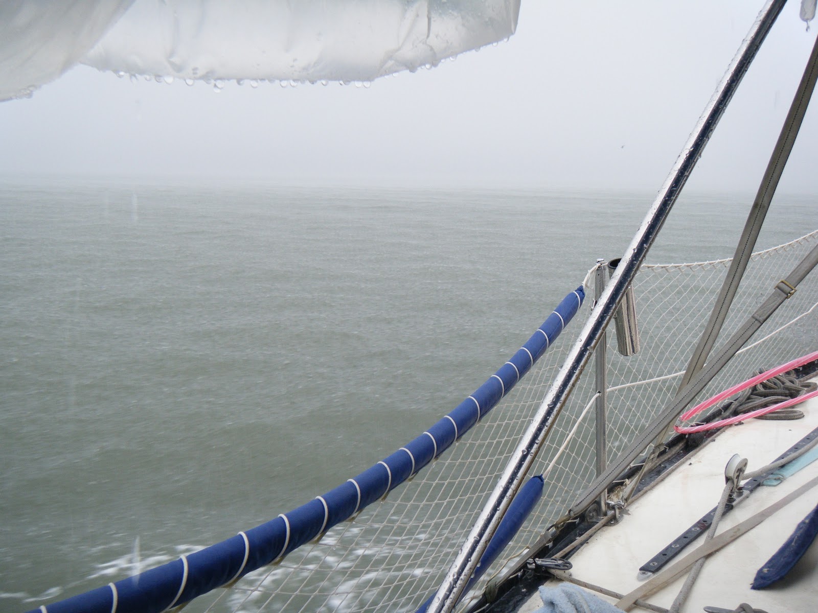
Tuesday was a wet day. It rained all day sometimes very hard. Visibility got bad but never too bad to stop. We anchored in Crescent River, mile marker 643. Now that we realize that our batteries are full and staying charged we can use a lil more electricity. Christine made coffee in the morning and we played Family Game Night 3 on our PS3 at night. We even were able to watch the weather on our tv!
This boat didn't make it

Wednesday joined our top three worst days (the other two are day 3 on the Chesapeake and the day after the snowstorm). The winds were about 20 mph with even larger gusts. This made it very cold since everything was wet the day before. The small rivers weren’t bad but crossing the Sounds was rough. The waves were about 3-4 feet, not as bad as that wavy day on the Chesapeake, but still enough to toss our boat around. One wave even crashed into our cockpit while I was at helm and soaked my pants. Then we would turn into the waves and they crashed onto our deck and sprayed the dodger. We eventually made it into Jekyll Creek which wasn’t east because of the jetties at the entrance. Rocks and waves make a scary entry. We anchored after the Jekyll Island Bridge at mile marker 685.
Garmin told us to keep this red to our left, bad Garmin!

Then the charts and Garmin told us to go inside another red marker and it looked safe but was not. We ran aground pretty good and then a boat behind us joined us aground. I got on their dinghy and we did some recon depth sounding with a string and weight. As soon we found where the shoal was and were able to get off and on our way. Luckily the tide was rising this time!

This cloud has a weary face just like we did

Just before Florida is a Nuclear Submarine landing zone. Awesome!

Today (Thursday the 27th) we left GA and made it to Florida! Georgia was our least favorite state and now we know why people skip it. We are currently anchored at Fernandina Beach, FL!
14 comments:
Less boats moving means higher likelyhood of being boarded. They like to yack about the courtesy inspection but it won't stop a boarding. Neither will waving around your passed inspection you just received (the one they said would be good for 6 months-right!)
I was concerned about boardings since you talked about just accepting some oil leak in the bilge. Part of the inspection (that they rarely do) is to see if there is excessive water or oil in the bigle.
Here's a fun thing to do though. Search the internet for anyone who says they were fined by the Coast Guard. I saw warnings and sometimes a ticket that would be voided if the violation was corrected in a certain amount of time- but no fines. Certainly not the 1000-5000 dollar ones they like to threaten.
Jay
We almost anchored in Crescent River last night but because we read about possibly needing 2 anchors, we opted for New Teakettle Creek.
We didn't suffer any issues in the Sounds today be we did hit all the bad spots at low tide!
Thanks for adding 'Spot' to your side bar! Its cool to watch your progress. Had to laugh about Georgia. My sentiments exactly, and thats strictly from my time on land. Although I have to admit Atlanta is the exception that proves the rule.
Take good care & enjoy!!!
Regarding the grounding, I assume you went aground at Marker 60 at N30.84970 W81.47916. (Please confirm) This grounding could have been avoided by reading ICW guides such as Dozier’s waterway guide which advises extreme caution between markers 58A and 62A. More info was available by reading other blogs such as http://thelastboat.blogspot.com/2008/11/sunday-november-23-2008.html. Planning your route and not relying on the maps maganta line would have allowed you to see that the red 60 in that area was in the wrong place as the chart shows deeper water on the west side of that marker. This would have alerted you to do further research on the area. Your tow boat company might also be willing to give advisories on very well known shoals like this one so they don’t have to come get you. Also free Coast Pilot files available at http://www.nauticalcharts.noaa.gov/nsd/cpdownload.htm give lots of useful info.
You can also learn from the mistake the boat behind you made. Never follow someone blindly and if they stop for no reason, you should be really concerned as to why!
Transiting at near high tide with the tide rising and checking for a clear route after grounding with the dinghy were both great moves.
You gotta stop these grounding before you get into areas with rock and coral.
Jay
Hey guys, glad to see that you're having fun. It has often been said that "if you ain't been aground, you ain't been around." It happens. I live in Charleston and work at the Maritime Center. I know Captain Woody with TowboatUS. You won't find a nicer guy anywhere.
As for the message above, Jay, they weren't relying on the magenta line when they ran aground, because they weren't in the ICW there. They were about a half mile south of the ICW at that point, so there was no magenta line there for them to follow anyway. Also, that marker is not in the wrong place. It's a daymarker, not a buoy, and since it isn't on the ICW, it should be kept to port when heading down-river towards the sea (as they were doing).
Also, I noticed in your picture on the left side of your blog that your jib-sheet is running inboard of your aft-most shroud. You should have your sheets on the outboard side.
One last thing... when I was in St. Augustine on my boat two years ago, I watched the Superbowl at "A1A Aleworks," which is right across the street from the St. Augustine Municipal Marina. It's a great place, and they make excellent beer there. Here's a link if you're interested: http://www.a1aaleworks.com/index.php?pg=location&sub=loc&location_id=20
Anyway, have fun, and keep the pics coming!
Chip
My statement regarding the magenta line was referring to an earlier post where they said instead of examining the charts and plotting their own route, they chose to rely on the maps magenta line. You reinforce my point regarding careful examination of the chart and plotting your own course as you point out the magenta line is not always available.
My belief that the marker may be in the wrong place is based the fact that it is part of a series on numbers. The numbers decrease as they go north back to the beginning where Jekyll Creek comes off the Brunswick River. This indicates that downstream is to the north from marker 60 and upstream is to the south. ( I know that the cumberland river may actually flow south but these kinds of conflicts sometimes show up. ) “Red right returning” indicates that red marker 60 should be on my starboard side as I go south Since the series of red markers previous to (and after) this one were taken on the starboard side why would you expect to take this one to port? . My charts shows shoaling on the east side of that marker and deep water on the west side of the marker. That’s a conflict to me.
I don’t know the shoaling in the area and I don’t know which side is actually clear for this marker. What I know is the chart shows a conflict and indicates further research for anyone planning a trip through here.
Also your statement of “since it isn't on the ICW” seems to indicate that all reds go on the same side of for the entire ICW. That isn’t true. In the Pungo River N35.44847 W76.57887(going south) they go on the port side. In Adams creek N34.89810 W76.68429 reds go to starboard as you go south. By the way did you notice the little yellow triangle on marker 60? That shows it is the ICW.
Jay
Jay, we are obviously talking about two different locations. Your example of the Pungo River is an exception to the rule that generally occurs where shipping and offshore/inshore channels intersect the ICW. Even during such exceptions, the ICW shapes (yellow triangle for red, yellow square for green) still indicate which side you should leave your markers to; triangle to stbd, square to port when heading southbound in the ICW.
I agree with you that the bottom line is that very close attention should be paid to where you are on the chart at all times.
My original post above stated the coordinates that I was assuming they went aground (I don't yet have confirmation of that). Perhaps you didn't check them and assumed I was talking about a different area?
My point was regarding which side reds or greens went on, not yellow symbols. I was concerned readers would interperet that there was a hard and fast rule regarding reds and greens on the ICW. The Pungo is not the only exception as you know.
If you want to discuss the yellow symbols, I will point out that the red marker 60 in the photo had a yellow triangle and as you say, that indicates you should take it to starboard as you go south. You previously said 60 should have been taken to port-maybe you didn't study the photo as closely as I did.
While I agree that you should know where you are on the chart at all times, my point to Bright Eyes was that they should plot out a course using Garmin Mapsource (or similar product) ahead of time and transfer that to their GPS. This allows them to double check their position. Once as they chart the course, looking or unusual areas or obstacles such as marker 60. Second as they zoom in (they were zoomed out when they went aground in Charlseton that depth markings didn't show) and follow the plotted course on the GPS.
Jay
Jay - We ran aground at 60A. The chart shows to keep the red marker to port heading south so we did, slowly. We hit ground and backed up and tried to go around 60A the other way but hit ground again. After doing the dinghy soundings we found that the shoal stuck out north from 60A so once we were at the marker we were now on the wrong side of the shoal. The boat behind us came in and tried to stay further to the west as the chart showed and also ran aground. Turns out you have to stay far east as you keep red 60A to your starboard and then favor the greens. The water was about 24 feet close to the east shore.
Chip - Thanks for the advice. The blog background pic is from when we first started sailing and that aft shroud is the main halyard. We did not know how to use the main sail at that time. We ended up spending happy hour at Pizza Alley, 4 beers and 2 slices of pizza for $1! thats not a typo.
Your description of the shoal should be very useful to others transiting this area.
The markers in this area are a mess. Marker 62a, in my opinion, shows the bottom here must have looked very different when these markers were placed.
What about the chart or the markers told you to take 60a to port going south?
I see a shoal 130 feet from 60a if I take it to port but I have 370 feet between 60A and the shoal to the north.
Since its red and all reds in this series should be taken to starboard going south, why would you break the rule for this one?
Jay
Jay - We took the red 60A to port because the Chartbook and Garmins magenta line clearly told us to. The shoal to the north is further away but there is also blue on the chart all north of the marker which usually indicates shallow water.
Ok if you have a magenta line, the I agree Gamin told you to take this marker wrong. I won't tell you again to make your own line-oops, I just did-sorry!
My Gamin version 2008.5 has no magenta line in this area at all. NOAA chart 11504 edition 17 02/01/2007 (available free online although there is probably a more updated version now) shows no magenta line. Let me know if you need a link to those free charts.
I agree that blue water generally indicates shallow water (6 feet or less) although in Charlseton when you where aground my garmin maps shows the areas of .5 feet and 17 feet as the same blue color so Garmin ain't perfect. In this area (60a) the blue water is supposed to indicate 6-12 feet (according to garmin) but there is no 6 foot depth line before the shoal to the north so I'd call that a garmin error also.
Since you were going slow I take it you already suspected something.
Jay
As I searched for more updated charts for this area I discovered some of the communication problems.
I was looking at garmin 2008.5 and NOAA Chart 11504 edition 17. In checking my 2006 Dozier's Waterway Guide, it said to use chart 11489 edition 36 (2005) (current at time of their printing). When I did that, I found your magenta line and as you said is shows to take that marker to port even though it is red. In 2007 NOAA printed 11504 which shows no magenta line and may not be the correct chart to consult for this area even in 2007 but this chart may have been used by garmin to produce 2008.5 which also shows no magenta line. In 2009 NOAA produced 11489 edition 38 which again shows the same magenta line in the same way as edition 36.
To further confuse things the markers move and change names through the various charts and editions. My favorite is 11489 edition 38 that shows 2 red markers named “60”!
For those interested the RNC charts can be found at http://nauticalcharts.noaa.gov/mcd/Raster/download.htm. I use Maptech Chart Navigator 5.07d but there are other programs that can read them as well. It looks like the newest version is 5.08 http://www.maptechnavigation.com/support/doc.cfm?docid=123&CFID=2568997&CFTOKEN=33866125 and should be free.
Sorry to write so much over one grounding but hopefully this illustrates to people how complicated navigation can be.
Jay
Thanks for the research Jay. Yeah as soon as we saw the magenta line telling us to keep the red to port we slowed down!
Post a Comment