We left Friday morning expecting another uneventful day.
Some bridge ruins.

The Charleston Bridge

Charleston

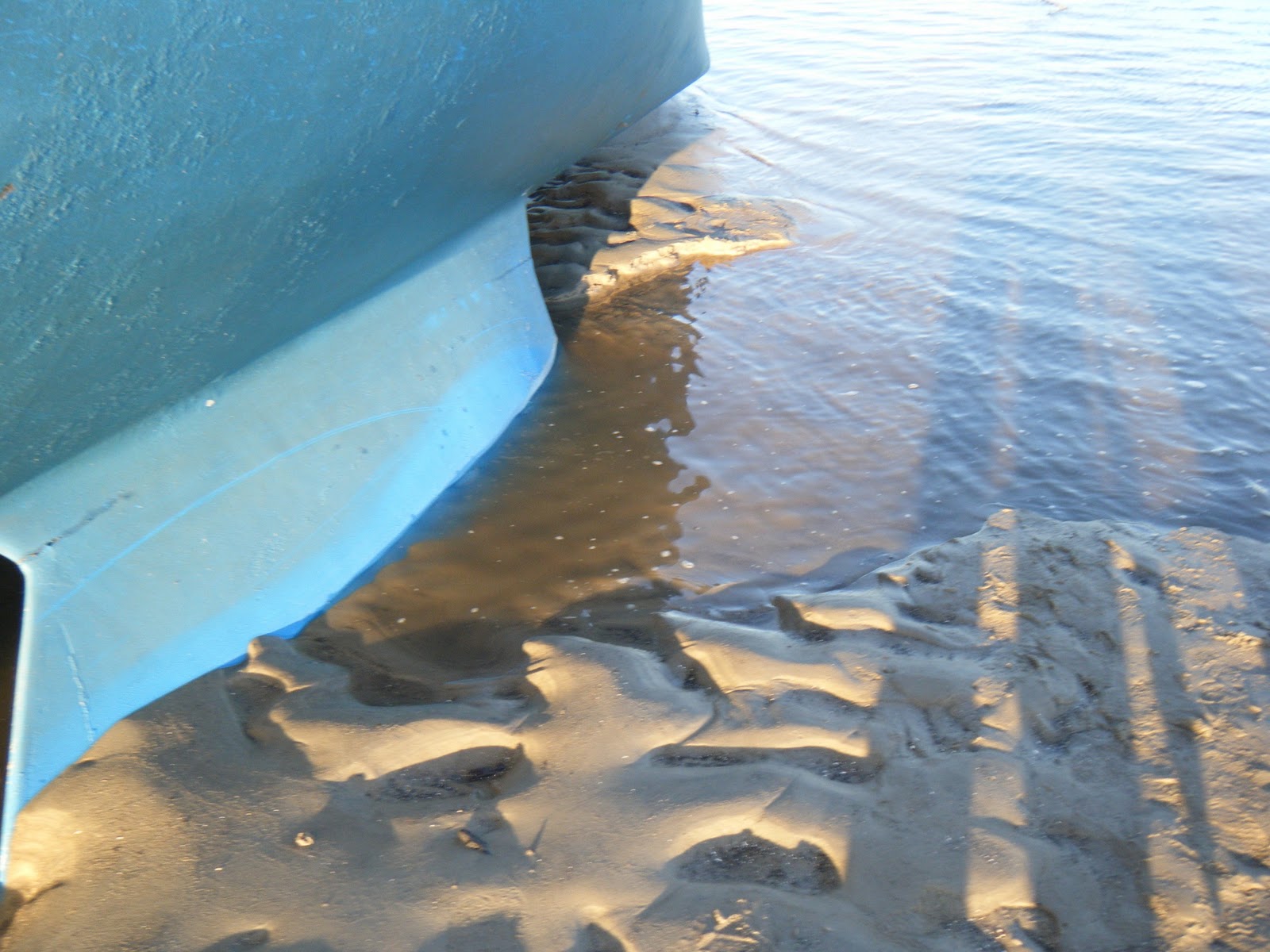
And then as we left Elliots Cut we decided to take a left off of the ICW to a marina for some much needed fuel. We could see the marina across the river and a boat anchored in between so I just headed over to it talking about how much fuel we needed. I tend to keep the Garmin zoomed out so I can see upcoming turns and markers, well this time I was zoomed out to far to read the depths. When I zoomed back in I saw that we were in 1 foot of water. I said to Christine, "this thing must be wrong cuz it says we are in 1 foot of water" and then BOOM!
Our boat ran aground and lurched forward. I turned right and spun the boat around and tried to get off the shoal but we hit it too hard and were stuck. It's ok we'll just call tow boat.
Tow boat got there about an hour later and during that time the tide dropped about a foot. We were now stuck and tilted sideways. The tow boat, Captain Woody, tried his best to get us off and even broke off one of our fair leads but we were stuck and he said there was nothing he could do. A lil panic sunk in, huh? What does that mean?
It was noon and he told us he would be back around 6 when the tide was back up and that there was a good chance we would be "high and dry". Christines face turned to terror. High and dry means we will be sitting on land.
Captain Woody sounded relaxed and and told us to clean the bottom of our boat and check our zincs and left. The boat was quickly tilting more and more sideways so we had to run down below and move everything to one side. This was happening whether we liked it or not. We called our boating mentor Eric and he assured us we would be fine and that he does it on purpose sometimes and alot of people do it to clean the bottoms of their boat. Erics words calmed Christine down and we were now able to relax and watch in amazement as the boat sat down on its side.
We attempted to dinghy out our anchor per Erics advice but the current was too strong and all I got was pictures. Soon we could see the ground and eventually we could hop right off the boat onto the newly formed island under our boat.
It was almost impossible to walk inside the cabin without getting sick so we stayed outside and ran around and enjoyed an unexpected day at the beach!


The island forming


I ended up just walking the anchor out and throwing it into deeper water. This will keep us from moving onto the shoal further when the tide comes back up.

Bright Eyes Island


We dug out that river behind our keel to help when we want to leave

A unique sunset

Bye Bye private island


Tho tow boat came back around 7:30 when the tide was up. We had straightened up by then and after a few tries we were floating again. We tossed the anchor and called it a night.
At first we were mad and scared about what we had gotten ourselves into, but in the end we are glad it happened and it was a very fun experience!
12 comments:
Pretty awesome!
A few things to point out.
First plan your trips ahead with Garmin mapsource or another similar product and then download that route to your GPS. This way you can zoom in on your planned route (pink line) and know as long as you are on that you are in the proper charted waters.
Second, I've never heard of anyone doing what you did on purpose. You could easily damage your rudder, prop and fiberglass hull (especially if you find a rock or other derbis as you lay down.)
I have, however seen boats lay down like that and when the water comes up the keel is so stuck that it holds the boat down and the boat floods especially if you get stuck in mud. I can get you pictures if you like.
Third you did not try (at least you didn't write about it) some techniques for getting yourself off the shoal. One that I know of is to take your anchor in your dinghy and set it out behind the boat as far as possible. After setting the anchor well you run the line to a jib winch and use the winch against the anchor to pull yourself off. This may work but with a falling tide it must be done very quickly.
You can also use a second anchor off to the side and shift weight within the boat to cause it to heel over making your draft effectively smaller.
Isn't it interesting that your tow boat didn't suggest any of these very well know ideas?
Your lucky he didn't try to hit you up for "Salvage towing" which usually isn't covered by tow contracts.
Jay
One of my favorite pieces of minutia states that "its the Pioneers that get the arrows" ie: learn from their mistakes. So glad ya'll are in good humor and 'rolling with it'. Joey, it's a guy thang "We don't need no stinkin maps!" and then we eat crow.
But I can gurantee ya, even if I'd known the tide was goin out, before ya heard/felt the BUMP, ya would've heard me say "We can make it."
Fair winds & following seas!
Miss ya'll
Amazing pictures! Between your post and the comments we're learning a lot. Glad it all worked out. As they say, it's not "if" you go aground, but "when"!
Good old Captain Woody!! He towed us back to our dock when we were in Charleston. A really nice guy. Here in the ICW, once you run aground when the tide is running out, almost nothing can be done until the tide starts coming back in. I watched the same thing happen to a boat that ran aground while we were waiting for a bridge. We ran aground yesterday but luckily it was just as the tide was coming in and a local guy helped pull us off. Just a warning; we are now at Mile 601 and since leaving Charleston, have experienced some very shallow waters during low tide (like 4 feet!). Be careful!
Your pictures are unbelievable!
Sorry, I did notice that you did try to anchor off the stern. I can't believe your dinghy couldn't fight the current. I wouldn't think the current would be over 3 knots.
I also wonder about an hour response from tow boat that close to Charsleton. Before you left Deale I pointed out that these guys probably don't sit in the boat waiting for a call in the winter like they might in the summer. Coverage? Yes...but when.
Jay
Two more points.
I was concerned by your comment "this thing must be wrong cuz it says we are in 1 foot of water"
The numbers on your chart tell you the "Mean Low Water". That roughly means that the average low tide will leave the amount of water shown on the chart. That area had a 6 foot high tide above mean low water that day. So at high tide you might have made it over the shoal but the tide was falling and was obviously shorter than your 4.5 foot draft.
The chart shows .5 to 1 foot for the shoal and you were high and dry because the low tide for that day was about .5 feet under mean low water.
The chart was not wrong. You didn't know the tide for the day and that area. So you should always know the high and low tide depths for areas you go through and you should always know whether the tide is rising or falling.
Also, I noticed there were two green markers in that area that you should have taken down your starboard side. That also would have kept you off the shoal. In elliot cut you took the greens to port but in the new body of water-the Stono you were headed out to sea so "red right returning" puts the greens to starboard.
Let me know if you need further clarification.
Jay
There are two types of sailors: Those who have run aground and those who haven't yet.
The pirates used to find a quiet cove and beach their ships while the tide ran out so they could careen and clean and repair the bottoms. You guys are like pirates :)
Here is some Coast Guard advice on grounding.
http://gulffishing.com/USCG_Running_Aground.html
You'll notice they make no exception for pirates, pioneers or maintenance when they say "Don't ground your boat"
I just hope people don't read this and think this is ok to do.
Jay
We anchored in the same creek you did just before the Ben Sawyer Bridge and woke up to the same tilted perspective. Floated at high tide. The Garmin is a great tool but it is only a guide, nothing beats the mark1 eyeball.
From 4.5 miles offshore of Flagler Beach. ETA Lauderdale 0900 on the 29th. Maybe we will see you on a mooring at Los Olas and discuss groundings over a few cold ones.
Bruce&Jan
Celtic Rover
Jay - We follow the Garmins pink line most of the time, but often there is a "miscommunication" and it thinks were are on land or we've even seen it tell us to go through a shoal, so we try not to completely rely on it. This time however it was 100% my fault, I just got distracted and didn't pay attention. I was very mad at myself.
I doubt we would ever try to ground our boat like that on purpose but several ppl including the tow boat captain said they have done it plenty of times. And I hope anyone reading this blog knows that it is not an informative blog. We are about as inexperienced at this as they come.
Our techniques to get off the ground include reverse, spinning the boat and high throttling forward, and praying. We did attempt to take the anchor out to prevent further grounding but our 3.5 hp engine on the dinghy was no match for the 3-4 knot current. One day we hope to try the boom tilting method. The tow boat Captain asked if Christine was a Boom Rider, sounds fun.
I would agree that the hour long tow response didn't help us in a falling tide.
Thank you for clarifying the chart numbers, I was always a lil confused about them. I'm guessing MLW means "mean low water". We now know how to read the tide charts on our Garmin so that should help in the future.
Thanks for the comments Jay, whenever we get into trouble we say, "O Jay is gonna love this" :)
Chet - I hear ya, I'm am constantly trying to prove the map wrong, I haven't won yet.
MLC - I like to think we are getting good at running aground :)
Laura and Hans - We keep a look out for you, I think we're a day behind. We aren't leaving Fernandina Beach till Sat morning tho.
Celtic Rover - Good to hear from you, we should have taken your advice and skipped GA. I guess we were still chicken.
Eric - Thanks a ton, your advice is invaluable!
MLW is indeed mean low water. You are also correct in not relying on the garmin entirely. No one source should ever be the answer. You might want to run your two GPS's side by side and replace the one that is showing you on land if the other does not.
"whenever we get into trouble we say, "O Jay is gonna love this" :)"
LOL- might I suggest you bore me for a while?
Jay
Post a Comment